Tuesday, 31 December 2024

HELP SAVE CLAREMONT ROAD

Corner of Grove Green Road and Claremont Road, 2nd August 1994
A year ago, I made a post titled Retracings which was the first of a short series revisiting photographs I had taken in 1993 and 1994 along the route of what was then called the M11 Link Road, now the A12, with photographs taken twenty years later, in 2013 and 2014, on the same dates showing the same viewpoints, or as close to the original viewpoints as was possible to recreate. There was one final set of photographs which I did not revisit in 2014 (or at least I have no memory of so doing and have not come across any negatives of this); earlier this year however, I did revisit these photographs, taken on the 2nd of August 1994, attempting to recreate them thirty years on. I didn't develop these new photographs at the time however, and have only scanned them recently. A new post on this set of images–from 1994 and 2024–a year on from my first post about the M11 Link Road to end the series seemed fitting.

A reason I may not have revisited this particular set of photographs in 2014 when I had done so for the others is that most of these pictures were taken on Claremont Road itself, which was almost completely wiped away by the building of the road–and there were only nine photographs from 1994. This was due to running out of film: I had been taking photographs around Wapping, Rotherhithe, and Greenwich earlier in the day, was on my second and last roll of film I had with me, and only got out at Leyton station, interrupting my journey home, in order to use the last few frames. I hadn't taken any photographs of the destruction along the route of the M11 Link Road since March that year: the camera I had been using, a Praktica BC1 (my first 35mm SLR and my first 'proper' camera) had jammed shortly after the last roll of film taken in March, and was uneconomical to fix. I didn't buy a new camera until the summer, finding a secondhand Praktica BCA body to replace the BC1 and keeping the original f1.8 50mm lens.

Grove Green Road, 2nd August 2024
Emerging from Leyton station that day, it was immediately clear that something was happening. Most of the photographs taken earlier that year are eerily devoid of people, partly as many were taken on Dyers Hall Road and Colville Road; the focus of the protests was Claremont Road–of which I had taken a number of photographs, but saw almost no one in all the times I was taking pictures–perhaps the protest activity only really began to make itself felt later in the year. Immediately I'd left the station I passed a number of police vans and ambulances, and then coaches with scores of police. Walking from Leyton station along Grove Green Road, the junction of the southern end of Claremont Road was blocked by police; I walked along Grove Green Road to the other end of Claremont Road, which was still open. The first photograph at the head of this post was taken at this corner, blocked with broken furniture, with a BBC news Land Rover parked alongside (there was a segment on the news on television that night, but filmed from before I arrived; I found this clip on YouTube filmed that day–about 11 minutes in–although the footage appears earlier in the afternoon). The second photograph is taken looking over where some houses had been demolished on Grove Green Road–the elevated position was taken from the Cathall Road bridge over the railway. The bridge is now wider and longer, but the picture from this August is pretty much from the same position. I did wonder if any of the trees could be the same, but I think all the trees in the photograph from 1994 are on the verge of Claremont Road which faced the Central Line (there were terraced houses on one side of Claremont Road only).


I must have then taken the next photograph after descending the ramp of the bridge, to Grove Green Road, looking across its junction with the northern end of Claremont Road. In the contemporary photograph below, there is the gable end of one of the new houses squeezed into the space remaining after the road was built. Five houses were demolished on this corner of Grove Green Road, then two new ones built into the site, which makes me think that the angle of the contemporary photograph is wrong–probably the grit bin to the left should probably be at the right edge of the view–the widening of both the bridge and the turning off Grove Green Road onto it are deceptive as to where this exact spot was in 1994. The angle of the photograph from 2024 does however include one of the transmitters from Graeme Miller's 'Linked' on the lamp post, upper right.


The rest of the photographs from the 2nd of August were taken on Claremont Road itself, now almost completely disappeared but for a small stub that remains at what was its southern end–Claremont Road was originally a loop, joining Grove Green Road at both ends–with some new houses built into the tight space behind the A12, so that Claremont Road, E11 still exists as an address. The photographs from 1994 were on Ilford Delta 400 film, which I had developed at Boots in Ilford: that summer, after leaving art college and no longer having access to develop black and white film myself (unlike the previous black and white photographs of the M11 Link Road, made while I was still at college), I mostly used Ilford XP2. In my second post on Ilford XP2 from 2018, a number of the photographs illustrating it were taken earlier the same day as the last M11 Link Road pictures here; the benefit of using XP2 of course was that it could be processed as C41, being cheaper and quicker when using a high street lab. I think I may have had the roll of Delta 400 as part of an offer, '3 rolls of film for the price of 2' or something like. XP2 has a very long tonal scale when developed as C41; the negatives on Ilford Delta 400 have very little shadow detail in comparison. I did not compensate in exposure when taking the photographs: the conditions that afternoon were overcast but quite bright–under the trees along Claremont Road, with the almost featureless sky in the centre of the viewfinder, made for some rather dark photographs. To attempt an approximation of the same angle and viewpoint of the images from 1994 below, I used a long lens–a Canon 135mm f3.5–from the Cathall Road bridge, looking along the A12 where once I had been facing down the length of Claremont Road.


There are a couple of photographs taken in 1994 on Claremont Road which look up to a platform across two of the houses, where there are protestors and photographers; trying to replicate the precise viewpoint, if it was possible, would now result in empty frames of sky. However, I did attempt to take photographs which at least looked in the same direction. These I took with the 135mm lens from the Roman Catholic Cemetery, pointing my camera across the Central Line and the A12 beyond towards the backs of houses on Grove Green Road. The roofs of the houses that the protestors and photographers are balanced on would have backed onto these. Here, I was limited in the exact viewpoint thanks to there being a screen of trees along the higher plots in that corner of the cemetery, so could only take photographs were there were gaps. The taller building behind with the twin gable ends in the pictures from 2024 is the three-storey Northcote Arms pub. Looking at contemporary maps from before the road, quite possibly I should have been taking photographs a little to the right of this–but the trees prevented me from accessing a more accurate viewpoint. (Two photographs from 2024, taken with a 50mm lens, show more of the context, and the position of the new houses on what remains of Claremont Road).


What appears to have happened earlier on the 2nd of August 1994 was the dismantling of a wooden tower on the roof of one or more houses further down Claremont Road, with protestors 'locked-on' in anticipation to frustrate or delay the planned demolitions. By the time I had arrived to take my handful of pictures, the action was essentially over, although I may just have caught the last of these protestors being removed by the cherry pickers before the houses at the end of the street could be safely demolished, although it's hard to see what is actually going on in the detail of these photographs from the distance I found myself. In 1994 I certainly could have used a longer lens, but at the time I had only the 50mm Prakticar lens from my original BC1–it would be nearly another year before I got a different focal length lens, a 28mm, buying a 80-200 zoom some time after. 

The image below is as close as I got to the line of police blocking the road, notably not all in riot gear, some in shirt-sleeves on that August day, providing space behind for the cherry pickers to do their work. Although I had sympathies in that direction, it's clear I was never really going to make a photojournalist: when I realised what I had walked into, I could have dashed to the high street in Leyton and bought another roll of film from somewhere, I could have found a better vantage point to take photographs, among those on the roofs. I didn't interact with any of the protestors: the previous photographs I'd taken on earlier occasions were an aesthetic project, devoid of people, which was what the first photographs were made for, although this was rather arbitrary to fit into a theme. Simultaneously, I realised I was creating a record of sorts, if entirely unsystematic and partial. Looking back, I wished I'd taken more photographs of course, as I've previously written.

It was serendipity that I happened to have nine frames remaining on the roll of film in my camera on that day, and that I made the decision to get off the Central Line train when I did–coming back from Greenwich on the Docklands Light Railway, I had changed to the Central Line at Bank, then had alighted at Stratford as I was on an Epping train and had thought to take the train to Ilford but with several minutes for that train, I got back on the Central Line, with a Loughton destination–and this might have prompted me to get out at Leyton, the very next stop.

I had no way of knowing that something was happening that day. In my first post, I mentioned the pre-internet media ecology of the mid-1990s, with the analogue alternatives at the time, such as SchNEWS; publications such as the Big Issue were also useful for alternative voices, set apart from newspapers and the four channels of terrestrial television sources. For the immediacy of an event like the evictions on the 2nd of August, one would have to had been local to know, or be part of that particular network (I knew precisely two people with mobile phones at the time). I did not going back to take any more photographs after that day–I had another six or seven weeks to do so before I left London to start my degree. Some of the photographs from the M11 Link Road were used in some etchings in my first year of my degree; as I wrote in Retracings, these photographs were part of my formative engagement with photography, learning the craft of the darkroom, all of which would be reiterated on my degree, with a new darkroom to get used to, and the time to become more deeply immersed in photography once again.


Tuesday, 17 September 2024

'The Image, the Frame, and the Off-Frame'


Although film-based photography only forms part of it (perhaps an important part however), my recently completed PhD thesis 'The Image, the Frame, and the Off-frame' is now available to read on the Royal College of Art's Research Repository here:-https://researchonline.rca.ac.uk/5889/

Tuesday, 26 March 2024

HOMES NOT ROADS

Dyers Hall Road, 26th March 1994
Revisiting my photographs of the M11 Link Road demolitions of 1993-94, I do find myself wondering why I didn't take more pictures. I had an awareness that I was documenting something and yet I wasn't at all systematic, and didn't think to keep notes about the photographs I was taking, which means that some pictures are very hard to locate, especially given the homogeneity of the terraced houses along the route. On 26th March 1994, which was a Satruday, I went out after lunch to go to the National Gallery (there was an exhibition of Claude Lorrain's work, including drawings); on my way, and got off the Central Line, to walk between Leytonstone and Leyton stations again. I took just eight photographs on colour film, many going back to houses I had photographed on black and white film taken earlier, but also took a couple on Grove Green Road, which (unless mistaken) I had not documented previously.

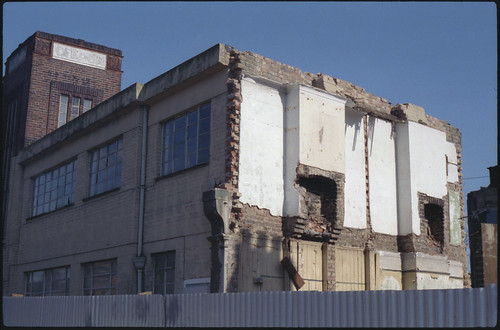
The first frame was of an industrial building on Grove Green Road, close to Leytonstone Station. On a map from 1950, this is marked 'printing works'. Looking back, I find I have no memory of what it was like to exit Leytonstone Station then, something I didn't think to photograph. Just past this short section of Grove Green Road outside the station, Church Lane ran underneath the railway to join up with the high street, something I don't remember; there is now a playground on the open space of the junction. Placing the first photograph from 26th March 1994, I relied on Tim Brown's photographs on Flickr: this particular building appears in a photograph (taken three days after I was there) alongside C&M Apostolides Ltd, which has a clear road number on its sign, locating the building in my photograph securely. I didn't know about Tim Brown's pictures in 2014 when I returned to revisit my images; the photograph below, taken on Grove Green Road in 2014 is very broadly in the same area, but not exactly the same view.


The next photographs are on Dyers Hall Road, where I took many of my pictures. There are three photographs of the house on the corner which I had first photographed on 31st December, then in the process of being demolished, rather more easy to replicate in 2014.


In my photograph from December 1993 of this particular house, one can see a blue plaque on the house (see Retracings), reading 'Our heritage–this house was once a home', an artwork by Paul Noble. This was evidently retrieved from the demolition: it appears in Fieldstudy No.9, and is listed there as being in the Museum of London.


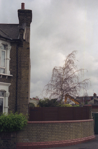
The next two photographs, one appearing at the head of this post, show a house on Dyers Hall Road that I had photographed on 18th February (see Photographs Not Taken), the end surviving building on the row backing onto the Central Line before the footbridge. The contemporary view simply shows the brick wall running alongside the A12.


There's a second photograph from Grove Green Road, after Dyers Hall Road rejoins it. This is a garage, which in 2014 I couldn't really place: the buildings on this side of Grove Green Road were demolished, but enough space remained after the road was built to create a long and narrow park, fittingly called the Linear Park. In 2014 there was a wall and railings separating the park from the road, which have now been removed and a cycle lane installed alongside the pavement that runs along it. I took a few photographs at different positions: not clear which might be the right one, I chose one with trees in blossom to stand in for the unknown precise location.


The last photograph is hard to place, a detail of a doorway of a demolished house. It could conceiveably have been on the section of Grove Green Road which is now the Linear Park, but I think it's more likely to be on Colville Road, possibly close to the Langthorne Road bridge, now a foot and cycle bridge. The 2014 photograph is again that of the brick wall along the A12 (the top of the footbridge can just be seen above the wall to the right).


The eight photographs taken on 26th March 1994 were the last I took for a number of months; this was at the start of the Easter holiday, so I wasn't travelling past the route of the road on the Central Line everyday, seeing the progression of the houses being demolished; shortly after being back at college for the summer term, my camera, a Praktica BC1 jammed. I was quoted £60 to send it away to be looked at without a guarantee that it could be fixed. It had cost £50 secondhand, a Christmas present, and so I was without a camera for a number of weeks until I found a Praktica BCA body for £26 to replace the body of the BC1 (the Bank of England inflation calculator shows these prices to be just double that today).

Monday, 18 March 2024

'WELCOME TO ESSEX'

Grove Green Road, 18th March 1994
Growing up in Ilford in the 1980s and 90s, its identity as being part of London was somewhat ambivalent: ‘London’ for me was something that happened after you got on the tube (and passed the destruction along the Central Line as the houses in Leytonstone were being demolished). Ilford had been part of the new London Borough of Redbridge established in 1965, but retained an Essex postcode, and in some respects it felt as though it faced out towards Essex along Eastern Avenue (to which the M11 Link Road would join as part of the approach to the Redbridge Roundabout) as much as into London in the other direction, and the quality of being on the edge of the urban sprawl was very evident: one had to only go to a number of stations on the Newbury Park loop of the Central Line to find the point at which the march of bricks and mortar were halted by the green belt. Despite being born in central London, and spending most of my childhood and adolescence in a London Borough, it was only leaving to study for my degree when I was defined (by others) as a ‘Londoner’.

The poster in the image above from which this post takes its name was advertising the album Essex by Alison Moyet, released the Monday after the day I took these photographs (as was the Deacon Blue single), named for the singer’s native county. Of the other music postered to the corrugated iron fence, Carter the Unstoppable Sex Machine had been popular among a certain section of the sixth form I’d recently left; the Soul Asylum record had been out for well over a year by the point I took the photograph, but possibly was being promoted after the single Runaway Train had won ‘Best Rock Song’ in the Grammys earlier that month. This arbitrary selection of posters might in some way indicate popular music at that point early in 1994: ‘Britpop’–however defined–hadn’t quite made itself felt culturally at that point; Parklife was released at the end of April, a few weeks after these photographs were taken.

On 18th March 1994, as on previous occasions,  I walked between Leytonstone and Leyton stations to take photographs along the route of the M11 Link Road. It had been a whole month since the last photographs, and I was aware that more buildings had gone in the weeks since, but I took less pictures, just nine frames, before getting back onto the Central Line and going to visit the Sir John Soane's Museum (where I took quite a few photographs), and the British Museum to see an exhibition on Victorian illustrated books, and bumped into someone I knew from school drawing from the Parthenon sculptures. I took no photographs on Dyers Hall Road, where I taken numerous pictures a month before. Instead, the sequence begins on Grove Green Road with two very similar photographs; this section of Grove Green Road became the Linear Park. In 2014, when I revisited the locations to take photographs twenty years on, the Linear Park had railings along the road–which have subsequently been removed.


I can't quite be sure that the photographs from 2014 were really in the right place–the facing terraced houses seen at the right of the bottom pair of images does provide some orientation, but the Linear Park represents quite a long stretch of road where numerous buildings–not just houses–were demolished. The weather on 18th March 1994 was similar to that of 18th February, the previous date I took a series of photographs, heavily overcast, although less misty. In 2014, it was sunny, and photographing into the light for a number of shots, the Prakticar f1.8 lens imparted some haze to many of these images.

The picture at the head of this post is the corner where the northern end of Claremont Road met Grove Green Road and used to feature a short parade of shops. That there is a billboard on the side of the house above the remains of number 153 on the corner suggests that this house had been demolished some time previously. The end of this terrace was pulled down to number 143; two newer houses were built adjoining 143 after the completion of the road, which can be seen in the picture from 2014, below. This end of Claremont Road has completely disappeared, making for a generous width of pavement and a more gentle angle for Grove Green Road to meet the rebuilt Cathall Road bridge, to the left of the picture below.


I took one photograph on Claremont Road itself, replicating a colour photograph taken in January at the southern end of the terrace facing the railway line; the remaining stub of this end of Claremont Road provides the opportunity to take a similar photograph, but in reality this should be shot from a position hovering over the A12.


The rest of the photographs were taken on Colville Road, some made standing on the remnants of garden walls to look over the fences, possibly reinstated from when I'd taken photographs a month before and had found a number of them torn down, and took some pictures from behind the fences. In the pair of images below, the picture from 2014 is too far to the left: the line of Colville Road was moved, and as a result the corner from 1994 would be under the current wall alongside the A12. 


As with a number of my other photographs, replicating the views in 2014 (and today) results in pictures of this brick wall, with little else to enliven the compositions. Many of the mature plane trees on the far side of the railway are still recognisably the same trees however, providing one point of reference when rephotographing.


The last two photographs from the 18th March were taken at the far end of Colville Road. Here, Langthorne Road crossed over the railway. Now a foot and cycle bridge, before the building of the A12 this was a road bridge, a presumably a cut through from Grove Green Road to the other side of the railway avoiding the high road. Langthorne Road has almost disappeared, the section that joined Grove Green Road being pedestrianised; in a similar fashion, at the other end of this stretch between the two Underground stations, Church Lane used to join Grove Green Road under the railway from the other side of Leytonstone Station. Now a a dead end road on the other side of the Central Line, Church Lane's junction with Grove Green became a playground and an approach to the footbridge which took its place.