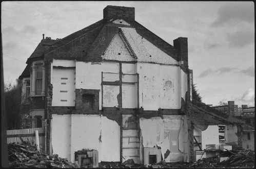
 |
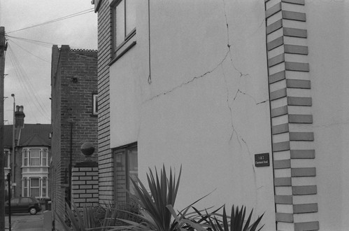
| Dyers Hall Road, Leytonstone, 31st December 1993 |
In a post that I wrote for this blog ten years ago, 'Twenty Years Since', I mentioned–almost in passing–photographs taken of houses being demolished to make way for what was then called the M11 Link Road, now the A12. The few words that described the experience of taking these photographs belies what was, in retrospect, an important formative experience or experiences. The taking of the these photographs was tied up with learning the craft of photography itself, following a basic introduction to photography as part of my Foundation Course in Art & Design a few weeks earlier, then receiving a secondhand Praktica BCA for Christmas in 1993.
I had been aware of the planning blight that accompanied the road scheme years earlier, although I hadn’t known that this was what it was. A journey into central London would involve taking the Central Line from Gants Hill or Redbridge stations; this branch of the Central Line is in a tunnel under Eastern Avenue, resurfacing just before Leytonstone station for a couple of stops, making this brief view from the windows of the tube train a diverting contrast to the darkness of the rest of the way. Houses backing on to the line where it runs above ground here had begun to be demolished or fall into disrepair years earlier: I distinctly remember the graffiti spelling out WHY BOTHER? on the back of a house from the late 1980s, later to provoke the rejoinder WHY NOT? (These were then joined by CRAWLING KING SNAKES KICK YO ASS.)
What had been an occasional journey while I was at school in nearby Wanstead became a daily one when I started college in 1993; I was all the more aware then that the demolitions were something that was actively happening, rather than what might have appeared to be a few streets fallen into desperate disrepair that I’d see whenever travelling into town. The protests around the tree on George Green in the autumn term was the moment that the active resistance to the road scheme made itself felt. (Rather pointlessly, one night after being kicked out of The George with a friend, we pulled down a fence post that had just been put up around the tree–there appeared to be no security at that stage–delaying the construction of the road by what must have been minutes at best, my only attempt at direct action).
The weather around Christmas in 1993 had been largely cold and wet, with some snow; the last day of the year, a Friday, turned fine and sunny, prompting me to decide that it was the perfect opportunity to use my new secondhand camera, with a roll of Ilford HP5 Plus bought for a holiday college project, which was to illustrate a number of words that we had been given. The photos are a record of that change in the weather. I took the tube to Leytonstone, and walked to Leyton, taking photographs along the way. I took some photographs in the British Museum afterwards on the same day; the last two photographs of the M11 Link Road sequence were taken from a moving train. These may have been from Leyton in the direction of Stratford, or I think I may have taken an eastbound train from Leyton back to Leytonstone, before then switching over (or under as the case is at Leytonstone) to take a Westbound train to Tottenham Court Road for the museum.
I returned on a number of occasions in the following months to take more photographs, neither systematic not comprehensive, but with the awareness that this felt like something of which it was worth making a visual record (the one time that I chanced upon evictions happening on Claremont Road in the summer of 1994, I had a part-used roll of film in my camera and no spare). The photographs were printed in the darkroom at college, rather inexpertly, and the images ended up used in artwork then, in collages and paintings, and I drew on these the following year when I’d left London and started a degree in Fine Art.
 |
| Dyers Hall Road, Leytonstone, 31st December 2013 |
I had occasion to revisit these photographs earlier this year, and needed to find the original negatives; in doing so I also found a set of negatives from 2013 in which I had attempted to match the locations from the photographs of what was then twenty ago as closely as possible. These negatives weren’t scanned at the time–I had intended a blog post then–and the moment passed. I had scanned the original negatives in 2007, and had posted these online in 2008, and rather over-promised the content of these images by calling this the ‘M11 Link Road Archive’ (an actual archive of material related to the M11 Link Road and the protests resides at the Museum of London). Returning to some of the original files, the quality of these original scans was relatively poor, with scanning artefacts and clipped highlights and shadows in many of the frames. (Scanning issues–software and hardware–partly explain the absence of posts on this blog this year, although the main excuse was the writing up of my PhD). Having found the negatives from both 1993 and 2013, I was able to scan these recently with better results for this post.
What I didn’t know at the time was that many of the houses along the route were or had been inhabited by artists. Acme Studios had been offered a number of the compulsorily-purchased houses by the Department of Transport in the 1980s; by the time I was taking these photographs, the houses along the route were occupied by the few original residents who had not moved away, some of the Acme artists who became involved in resisting the demolitions, and the first wave of anti-roads protestors, some of whom had come from Twyford Down, just outside Winchester–where I was going on to study–and many subsequently moved onto to protest the Newbury Bypass after the M11 campaign.
For a few years I probably didn’t think about this part of my life very much; I happened to cycle over the road on the Quartermile Lane bridge from Hackney just before it opened in 1999. I didn’t have a camera on me at the time, and thought I’d return to take photographs of the empty road, but I never did. Then in 2003, a site-specific sound piece by the artist Graeme Miller called LINKED was installed along the route. This required collecting a radio receiver and headphones, available from local amenities–we got ours from Wanstead Leisure Centre–and walking a route from Wanstead to Hackney Wick, along which one would encounter transmitters that broadcast audio loops consisting of extracts of oral history weaved with music into soundscapes.
Related to Miller’s LINKED, in 2008 I attended a number of seminars at LCC’s Photography and the Archive Research Centre (PARC), part of their research project Road: Artists and the Stop The M11 Link Road Campaign, 1984–1994; the ninth issue of PARC’s journal, Fieldstudy, was devoted to this research project, and featured a few of my photographs from 1993-94. Last year, Graeme Miller revisited LINKED: since its initial installation, with most of the receivers being placed on lamp posts along the road, a slow attrition had reduced these in number over time, some going as the Hackney Wick end of the route was swallowed up by the 2012 Olympic Park, others from the streetlights being knocked over, or the transmitters being unknowingly discarded by contractors. In anticipation of the project’s 20th anniversary, Miller revisited it for Re-LINK last year where the receivers were made available again for 48 hours and a roundtable discussion was hosted by Leytonstone Library; in conjunction with the exhibition Radical Landscapes at the William Morris Gallery, three open days for LINKED were planned, the first was in November, the next on 20th January and 17th February 2024. (In the intermediate years I had other opportunities to revisit Miller’s LINKED a few times, re-walking the route in different groups, thanks to the artwork being used as a PhD case study by Dr. Sarah Wishart.)
In 2013, attempting–as best I could–to find the same viewpoints as the photographs taken in 1993, it wasn’t always clear as to where exactly each picture had been taken then: I hadn’t taken any notes. However, the sequence on the contact sheet, and the linear nature of the route from station to station made this relatively easy in most cases, but for some photographs this would have meant hovering above the A12 itself, as with most of those taken along Claremont Road itself. Some of the photographs in my retracings from 2013 and 2014 were taken with a Zenit 11, some with Praktica MTL3, but for both cameras I used a Prakticar f1.8 50mm lens, the same design lens as I would have had on my Praktica BC1, and then the BCA which replaced it later in 1994 (Edit 25/01/24: Having rediscovered the contact prints from the photographs taken on the 31st December 2013, I had actually used an Olympus OM10 for this set of photographs).


Fieldstudy issue 9 (PDF file)
Graeme Miller LINKED
Sarah Wishart, 'A Provenance of Performance'
SchNEWS Issue 3 December 1994
Dean L. Biron, 'Writing and Music: Album Liner Notes'