 |
| Claremont Road, Leytonstone, 16th January 1994 |
As described in my previous post, ‘Retracings’, after the first set of photographs of the destruction along the route of the M11 Link Road, I returned on subsequent occasions through the first months of 1994 to take more pictures. The next set of photographs was taken on the 16th of January, a Sunday. For these I used a colour film, according to the film rebate, Kodak Gold 100. I didn’t take very many photographs–nine–and three of them almost exactly replicated those shot on black and white film just over two weeks earlier as featured in my last post; I hadn’t, at that point, developed the black and white film. The colour film was developed the following week, before the black and white film, probably at Boots or Jessops in Ilford, dropped off before college one morning and picked up a couple of days later. The black and white film was not developed until the second week of February, partly due to the periodic absence of the photography technician, from which one had to borrow developing tanks, as well as lenses to use the enlargers, signed out and signed back in from a cubby hole.
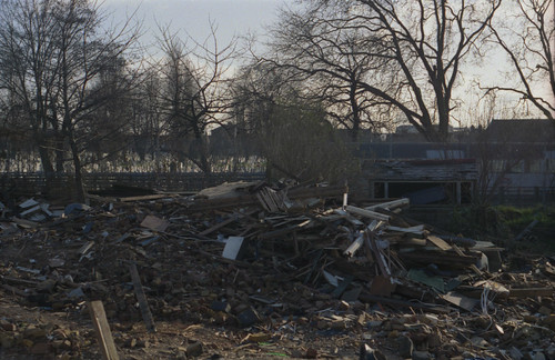
I did take more photographs on the short southern end of Claremont Road, where more houses had been demolished in the intervening weeks, with a sequence of four images from the end of the terrace facing the Central line, around to the section of the road where it rejoined Grove Green Road: this begins with the image below with the NO M11 graffiti, and ends with the image at the top of this post. These obliquely show some of the murals painted on the corrugated iron hoardings, and the painting on the houses, which became more prominent in the summer of 1994 along Claremont Road, functioning somewhat like an open air art gallery.


In January 2014, I retraced the route again, and photographed some of the same sites on colour film (the film rebate tells me that this was a Boots 200 ISO film, almost certainly out of date by the time I used it): the locations of the above three frames from Claremont Road would now be directly over the A12; the last image of this sequence, the photograph at the top of this post would have been relatively close to the remaining stub of Claremont Road (although almost certainly to the right), which I photographed in 2014, below.

Of the photographs that replicated those taken previously on black and white film, one was from the footbridge over the Central Line from Dyers Hall Road; the other two were on Colville Road. One of the 2014 versions of the Colville Road photographs shows more of the trees in the cemetery on the far side of the road and Central Line, which clearly shows that these are the same. The angle of the second image is almost certainly less accurate.


Having walked the route from Leytonstone to Leyton stations as I had done in December 1993, I then got the tube to Wanstead, where I got out to take a couple of photographs from the footbridge over Eastern Avenue. One of these, looking southwest towards a couple of houses which were demolished to provide space for a slip road off Eastern Avenue before it enters the cut-and-cover tunnel under George Green the road, and, parallel to this, to join Wigram Road to Elm Close, the latter road otherwise having been entirely marooned by the new road scheme. The new footbridge also needed to be wider and a wall built to mitigate the traffic noise for those residents that remained.


I also took a photograph from the footbridge looking in the opposite direction, northeast, towards Claybury. The house nearest to the bridge was boarded up at the time, and I suppose I must have thought that this too was to be demolished. The photograph taken in 2014 shows the same house with a large extension to its side; possibly the windows were boarded in anticipation of this building work–or it might have been under the threat of demolition, but this was not necessary for the road as built. The photograph above also shows extensions and attic conversions visible across the nearest row of houses: the two semi-detatched houses on the end are nearly unrecognisable as a result. The graffiti in the photograph from 1994 includes the motto DAMP SQUIBB: Squibb was the name emblazoned on the plant machinery responsible for much of the demolition, but was also used as something of a tag–perhaps in an accusatory manner–in the graffiti used along the route, visible again on the corrugated iron in the first photograph taken in December 1993 on Dyers Hall Road.


No comments:
Post a Comment