 |
| Grove Green Road, 18th March 1994 |
Growing up in Ilford in the 1980s and 90s, its identity as being part of London was somewhat ambivalent: ‘London’ for me was something that happened after you got on the tube (and passed the destruction along the Central Line as the houses in Leytonstone were being demolished). Ilford had been part of the new London Borough of Redbridge established in 1965, but retained an Essex postcode, and in some respects it felt as though it faced out towards Essex along Eastern Avenue (to which the M11 Link Road would join as part of the approach to the Redbridge Roundabout) as much as into London in the other direction, and the quality of being on the edge of the urban sprawl was very evident: one had to only go to a number of stations on the Newbury Park loop of the Central Line to find the point at which the march of bricks and mortar were halted by the green belt. Despite being born in central London, and spending most of my childhood and adolescence in a London Borough, it was only leaving to study for my degree when I was defined (by others) as a ‘Londoner’.
On 18th March 1994, as on previous occasions, I walked between Leytonstone and Leyton stations to take photographs along the route of the M11 Link Road. It had been a whole month since the last photographs, and I was aware that more buildings had gone in the weeks since, but I took less pictures, just nine frames, before getting back onto the Central Line and going to visit the Sir John Soane's Museum (where I took quite a few photographs), and the British Museum to see an exhibition on Victorian illustrated books, and bumped into someone I knew from school drawing from the Parthenon sculptures. I took no photographs on Dyers Hall Road, where I taken numerous pictures a month before. Instead, the sequence begins on Grove Green Road with two very similar photographs; this section of Grove Green Road became the Linear Park. In 2014, when I revisited the locations to take photographs twenty years on, the Linear Park had railings along the road–which have subsequently been removed.


I can't quite be sure that the photographs from 2014 were really in the right place–the facing terraced houses seen at the right of the bottom pair of images does provide some orientation, but the Linear Park represents quite a long stretch of road where numerous buildings–not just houses–were demolished. The weather on 18th March 1994 was similar to that of 18th February, the previous date I took a series of photographs, heavily overcast, although less misty. In 2014, it was sunny, and photographing into the light for a number of shots, the Prakticar f1.8 lens imparted some haze to many of these images.
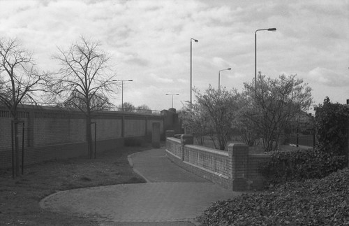
The picture at the head of this post is the corner where the northern end of Claremont Road met Grove Green Road and used to feature a short parade of shops. That there is a billboard on the side of the house above the remains of number 153 on the corner suggests that this house had been demolished some time previously. The end of this terrace was pulled down to number 143; two newer houses were built adjoining 143 after the completion of the road, which can be seen in the picture from 2014, below. This end of Claremont Road has completely disappeared, making for a generous width of pavement and a more gentle angle for Grove Green Road to meet the rebuilt Cathall Road bridge, to the left of the picture below.

I took one photograph on Claremont Road itself, replicating a colour photograph taken in January at the southern end of the terrace facing the railway line; the remaining stub of this end of Claremont Road provides the opportunity to take a similar photograph, but in reality this should be shot from a position hovering over the A12.


The rest of the photographs were taken on Colville Road, some made standing on the remnants of garden walls to look over the fences, possibly reinstated from when I'd taken photographs a month before and had found a number of them torn down, and took some pictures from behind the fences. In the pair of images below, the picture from 2014 is too far to the left: the line of Colville Road was moved, and as a result the corner from 1994 would be under the current wall alongside the A12.


As with a number of my other photographs, replicating the views in 2014 (and today) results in pictures of this brick wall, with little else to enliven the compositions. Many of the mature plane trees on the far side of the railway are still recognisably the same trees however, providing one point of reference when rephotographing.


The last two photographs from the 18th March were taken at the far end of Colville Road. Here, Langthorne Road crossed over the railway. Now a foot and cycle bridge, before the building of the A12 this was a road bridge, a presumably a cut through from Grove Green Road to the other side of the railway avoiding the high road. Langthorne Road has almost disappeared, the section that joined Grove Green Road being pedestrianised; in a similar fashion, at the other end of this stretch between the two Underground stations, Church Lane used to join Grove Green Road under the railway from the other side of Leytonstone Station. Now a a dead end road on the other side of the Central Line, Church Lane's junction with Grove Green became a playground and an approach to the footbridge which took its place.


No comments:
Post a Comment